لە ژێر چاودێری بەڕێز پرۆفیسۆر دکتۆر (کامران یونس محمدامین) سەرۆکی زانکۆی سەڵاحەدین-هەولێر،یەکەی چاودێری ژینگە وگۆڕانی ئاووهەوا لە بەرێوەبەرایەتی گشتی سەنتەری توێژینەوەی زانستی - زانکۆی سەڵاحەدین–هەولێر بە خۆشحاڵیەوە سیمپۆزیۆمێک ڕیکدەخات بە بۆنەی بەرز ڕاگرتنی
ڕۆژی جیهانی سیستەمی زانیاریە جوگرافیەکان (GIS Day 2025):
لە ژێر ناونیشانی:
کۆربەندی ڕێگاچارەی شوێنجێی بۆ پەرەپێدانی بەردەوامی ژینگەیی وئاسایشی ئاو
Geospatial Solutions for Environmental Sustainability and Water Security Symposium.
ئەم سیمپۆزیۆمە پسپۆڕانی ئەکادیمی، مامۆستیان و بەرپرسانی زانکۆ وقوتابیان، وبڕیاردەران لە وەزارەتە جیاوازەکانی حکومەتی هەرێم کۆدەکاتەوە بۆ تیشک خستنە سەر ڕۆڵی گرنگی سیستەمی زانیاری جوگرافی (GIS) وهەستکردن لە دوورەوە لە ڕێگاچارەی ئاڵەنگاڕیەکان وگەشەپێدانی بەردەوامی ژینگە لە میانی گۆڕانکاریە ئاو هەواییەکان.
لە ئیڤینتەکەدا سێ قسەکەر بانگهێشتکراون بۆ پێشکەش کردنی سێ بابەت کە پێکهاتوون لەم بەڕێزانە:
- بەڕێوەبەری دانیشتن: پ. ی. د. هونەر عبدالله كاك أحمد
- د.هێمن عبدالخالق گەزنەیی:
Applications of GIS for Climate Change & Environmental Management.
- د. تحسین عبدالرحیم عزیز:
Role of Geospatial Technology (GIS) in Water Resource Management.
- - د. کیوان کریم خان فتاح:
Automated Landform Classification and Landslide Susceptibility mapping improve disaster preparedness and land management practices.
بە گەرمی بانگهێشتی ستافی ئەکادیمی، توێژەران، قوتابیان، ونوێنەرانی ڕێکخراوە حکومی وناحکومییەکان دەکەین بۆ ئامادەبوون وبەشداریکردن.
تێبینی: بەشداری کردن بە خۆڕاییە و دوای کۆتایی هاتنی سیمپۆزیۆمەکە ئامادەبووان بڕوانامەی بەشداری کردنیان پێ دەبخشرێت.
بۆ بەشداری کردن تکایە سەردانی ئەم بەستەرەی خوار بکەن
https://forms.gle/9TyojZf5Zb9iRr18A
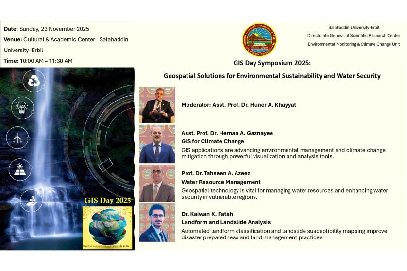
ڕێکەوت: یەکشەممە، ٢٣ی تشرینی دووەمی ٢٠٢٥
شوێن: سەنتەری ڕۆشنبیری وئەکادیمی - زانکۆی سەڵاحەدین–هەولێر
کات: کاتژمێر ١٠:٠٠ بەیانی – ١١:٣٠ بەیانی
English:
Under the supervision of Professor Dr. Kamaran Younis M. Amin the president of Salahaddin university-Erbil, The Environmental Monitoring and Climate Change Unit at the General Directorate of Scientific Research Center - Salahaddin University–Erbil (SURC). On World GIS Day is pleased to announce organizing of a Symposium in Title of:
GIS Day Symposium 2025:
Geospatial Solutions for Environmental Sustainability and Water Security.
This symposium will bring together academic experts, university leadership, postgraduate and undergraduate students, and key decision-makers from various KRG ministries to highlight the critical role of Geographic Information Systems (GIS) and Remote Sensing in addressing today’s environmental and water-related challenges.
The event will feature Three invited speakers presenting research and applied case studies on:
- Moderator: Asst. Prof. Dr. Huner Khayyat
- Dr. Heman Abdulkhaleq Gaznayee
Applications of GIS for Climate Change & Environmental Management.
- Prof. Dr. Tahseen Abdulraheem
The Role of Geospatial Technology (GIS) in Water Resource Management.
- Dr. Kaiwan K. Fatah
Automated Landform Classification and Landslide Susceptibility Mapping improve disaster preparedness and land management practices.
This event represents an important platform for exchanging knowledge, strengthening collaboration between academic and government institutions, and highlighting the growing impact of geospatial technologies in environmental monitoring and climate resilience.
We warmly invite academic staff, researchers, students, and representatives of governmental and non-governmental organizations to attend and participate.
Note: Registration is free and All attendees will receive an official Certificate of Attendance upon completion of the symposium.
To register: Please click the link below:
https://forms.gle/pjUeot5zLWraPHPe8
Date: Sunday, 23 November 2025
Venue: Cultural & Academic Center - Salahaddin University–Erbil
Time: 10:00 AM – 11:30 AM